- Published:
Reorganisation of the Triassic stratigraphic nomenclature of northern Switzerland: overview and the new Dinkelberg, Kaiseraugst and Zeglingen formations
Swiss Journal of Geosciences volume 109, pages 241–255 (2016)
Abstract
In the context of the harmonisation of the Swiss stratigraphic scheme (HARMOS project), the stratigraphic nomenclature of the Triassic sedimentary succession of northern Switzerland has been reorganised to six formations (from base to top): Dinkelberg, Kaiseraugst, Zeglingen, Schinznach, Bänkerjoch, and Klettgau Formation. The first three are formally introduced in this paper. The Dinkelberg Formation (formerly «Buntsandstein») encompasses the siliciclastic, mainly fluvial to coastal marine sediments of Olenekian to early Anisian age. The formation is some 100 m thick in the Basel area and wedges out towards southeast. The Kaiseraugst Formation (formerly «Wellengebirge») comprises fossiliferous siliciclastic and carbonate sediments documenting a marine transgressive—regressive episode in early Anisian time. It starts with sandstone, dolomite, continues with subtidal limestone and marl and ends with bituminous shale and supratidal dolomite. Thickness decreases from approximately 50 m in the High Rhine area to 10 m in the south and east. In the Lake Constance area, a transition to the siliciclastic marginal facies of the Vindelician High (Eschenbach Formation in Germany) is documented by borehole evidence. The Zeglingen Formation (formerly «Anhydritgruppe») documents a regressive marine evaporitic megacycle during the Illyrian (late Anisian). At most places, except in far eastern Switzerland, it starts with massive halite deposits. It continues with sulfate and marl sequences and ends with littoral stromatolitic dolomite. In the WSW–ENE trending depot centre total formation thickness is 150 m and more, and thickness of salt layers reaches up to 100 m. In the High Rhine area, the thickness is reduced due to subrecent subrosion. At some places evidence points to syn- to early-post-diagenetic erosion. For practical reasons, the six formations are organised in three lithostratigraphic groups: Buntsandstein Group (with the Dinkelberg Formation), Muschelkalk Group (combining the Kaiseraugst, Zeglingen and Schinznach Formations) and Keuper Group (combining the Bänkerjoch and Klettgau Formations).
1 Introduction
1.1 Motivation and concept
The Triassic succession of northern Switzerland (Fig. 1) encompasses around 225–550 m of marine to terrestrial sediments (Fig. 2). Classically, they have been subdivided in «Buntsandstein», «Muschelkalk» and «Keuper». In the published sheets of the Geological Atlas of Switzerland 1:25,000, the «Muschelkalk» is subdivided, from base to top, in «Wellengebirge», «Anhydritgruppe», «Hauptmuschelkalk», and «Trigonodusdolomit». «Buntsandstein» and «Keuper» are usually taken as complete, undivided mapping units. Only in areas of flat-lying strata and good outcrop conditions, for instance in the Klettgau area, a further subdivision was introduced for «Keuper» with additional map signatures. The classification used in the explanatory notes of the Atlas sheets and the description of the respective core sequences of the deep boreholes are compiled in Fig. 3.

Outcrop area and thickness of the Triassic strata in northern Switzerland and localization of complete Triassic sections. Abbreviations (wells): BK Benken, BR1 Berlingen 1, BS1 Basel 1, BX Buix, EN1 Entlebuch 1, HE1 Herdern 1, KZ1 Kreuzlingen 1, LI1 Lindau 1, OT2 Otterbach OT2, PF1 Pfaffnau 1, RK Riniken, RL2 Rietheim L2, RU Ruckfeld, SH Schafisheim, SI Siblingen, SL1 Schlattingen SLA-1, SO Sonnengarten GTB1, WE Weiach, WE2 Weiach 2, ZT1 Zurzach T1, ZT3 Zurzach T3, ZZ1 Zurzach Z1

Simplified section of Triassic strata in northern Switzerland [this paper, Pietsch et al. 2015 (submitted/this volume), Jordan et al. 2015 (submitted/this volume)] and correlation with the current stratigraphic scheme of adjacent Germany (Geyer et al. 2011). Markerbed 1 and 2 of Bänkerjoch Formation according to Nagra (2001) and Jordan et al. (2015) (submitted) Fm. Formation, Mb. Member

Correlation of formerly used terms and actual stratigraphic scheme of southern Germany (High Rhine area) (Geyer et al. 2011) ans adjacent France (équipe du projet GeORG 2013) with the actual Dinkelberg Formation, Kaiseraugst Formation and Zeglingen Formation (this paper). BSst. Buntsandstein, Fm. Formation, HM Hauptmuschelkalk, Indu. Induan, Mb. Member, r Rotliegendes, z Zechstein
None of the units in use have ever been formally defined. In the context of the harmonisation of the Swiss stratigraphic scheme [HARMOS project, Morard et al. 2012; Strasky et al. 2015 (submitted/this volume)] it was decided to revise the stratigraphic nomenclature of the Triassic strata of northern Switzerland following the guidelines of the Swiss Committee on Stratigraphy (Remane et al. 2005). Several approaches have been evaluated. One rejected approach was the adoption of the recently revised stratigraphic scheme of southwestern Germany, recapitulated in Geyer et al. (2011). In German areas adjacent to northern Switzerland, more than 20 formations are in use to describe the Triassic succession. However, many of the formations, having considerable thicknesses in the centre of the Central European Basin, are only represented by a few metres of sediment along the River Rhine. Following the concept of Remane et al. (2005), a formation represents a mappable unit. Consequently, according to the Swiss Geological Survey a formation should be at least some 30–50 m thick, to be represented on the 1:25,000 sheets of the Geological Atlas of Switzerland.
Another approach was to formally consolidate the current Swiss scheme, because many outcrop studies and deep boreholes were recorded according to the traditional stratigraphic nomenclature. This was supported by the argument, that existing map units should be maintained, especially from the perspective of a Swiss-wide harmonisation. Finally, a pragmatic approach has been preferred, which is mainly based on the traditional Swiss scheme, though with some important divergences which will be discussed later in this paper.
1.2 Outcrop conditions and additional data source
The concept of Remane et al. (2005) asks for accessible outcrops as type sections. Since the outcrop conditions of Triassic units are today often bad, a mixed concept of superficial type sections and—mostly borehole based—reference sections had to be established for the present task. The requirement for a borehole based reference section is that the core material is properly stored and accessible for future research. Finally, type and reference sections should be published in papers or reports that are accessible to the public. Initially, no additional field or laboratory work was planned to revise the Triassic stratigraphic nomenclature.
In northern Switzerland, the «Buntsandstein» (now Dinkelberg Formation) and the «Unterer Muschelkalk» or «Wellengebirge» (now Kaiseraugst Formation) outcrop only in the area between Mumpf AG, Wintersingen BL and Riehen BS. The outcrops have always been mostly poor exposed except along the banks of the River Rhine, particularly between Rheinfelden AG and Kaiseraugst AG. These outcrops have been meticulously documented by Brändlin (1911) and Disler (1914) before they have been flooded after construction of hydroelectric dams. In addition, these «Buntsandstein» and «Unterer Muschelkalk» levels have been reached by some deep boreholes (Fig. 1). Since the work of Disler (1914), the outcrops of these strata in northern Switzerland have never been subject to further regional stratigraphic studies anymore.
Natural outcrops of the «Mittlerer Muschelkalk» or «Anhydritgruppe» (now Zeglingen Formation) are rare due to subrosion of gypsum and halite. However, intensive drilling on rock salt deposits along the River Rhine between Basel and Bad Zurzach AG, some gypsum quarries (e.g., Zeglingen BL, Kienberg SO and Felsenau near Full AG) and deep boreholes farther south (Fig. 1), yield sufficient information about this stratigraphic interval. In the southwestern part of the considered area, the «Mittlerer Muschelkalk» has acted as main décollement horizon for the late Miocene Jura fold-and-thrust belt (e.g. Jordan 1992). Stratigraphic studies on this interval have been published, among others, by Disler (1914), Merki (1961), Hauber (1971), Dronkert et al. (1990) and Widmer (1991).
The 50–85 m thick, dominantly calcareous «Oberer Muschelkalk» (now Schinznach Formation) including «Trigonodusdolomit», «Hauptmuschelkalk» and «Lettenkohle», outcrops at many places in the frontal part of the Jura fold-and-thrust belt (Folded Jura) as well as in the adjacent Tabular Jura from Basel up to the Wutach Valley, north of Schaffhausen. Nevertheless, complete sections including both the base and the top of the Schinznach Formation are rare. Here again, borehole information helps to complete the knowledge (Fig. 1). Stratigraphic studies of this interval have been published, among others, by Schalch (1916), Disler (1914), Paul (1936, 1956, 1971), Merki (1961) and Gsell (1968). In the context of a sedimentological study, several new and already known outcrops and borehole sections have been recorded [Pietsch et al. 2015 (submitted/this volume)].
Outcrops of the «Gipskeuper» (now Bänkerjoch Formation) are also rare due the evaporitic nature of the unit. However, it was encountered in boreholes, tunnels and gypsum quarries, where it has been stratigraphically described, among others, by Schindler (1962), Prasad (1970), Dronkert et al. (1990), Rick (1990) and Meier (2011).
The upper part of the «Mittlerer Keuper» and the «Oberer Keuper» (now Klettgau Formation) are quite heterogeneous with significant local and regional variations. They include the «Schilfsandstein», «Untere Bunte Mergel», «Gansingen Dolomit», «Obere Bunte Mergel», «Stubensandstein», «Knollenmergel» and «Rhät». An excellent and nearly complete insight is given today in the Gruhalde clay pit in Frick AG. Another excellent, but temporary outcrop was documented by Bitterli-Dreher et al. (2007) during the construction of the Ennetbaden by-pass tunnel. Further outcrops can be found all along the Folded and Tabular Jura from River Birs in the West up to the upper Klettgau area (north of Schaffhausen) in the East. Some of these outcrop sections have been recently newly recorded by Jordan et al. (2015) (submitted/this volume). Finally, again borehole information helps to correlate and complete the outcrop information (Fig. 1). Regional stratigraphic studies have been published by Erni (1910), Brändlin (1911), Disler (1914), Gsell (1968), Bläsi (1995) and Etzold and Bläsi (2000). Local information on mineralogy and fossil record comes from Peters (1964) and Wildi (1976), respectively.
1.3 Methodology
In a first step, six formations have been outlined based on literature study (Fig. 2). The concept focusses on lithology and the respective sedimentary environments (normal marine to estuarine or littoral, evaporitic, terrestrial):
-
The Dinkelberg Formation corresponds to the former «Buntsandstein» and represents a mainly fluvial to coastal environment.
-
The Kaiseraugst Formation corresponds to the former «Wellengebirge» («Unterer Muschelkalk») and represents a marine sub-, inter- and supratidal environment.
-
The Zeglingen Formation corresponds to the former «Anhydritgruppe» («Mittlerer Muschelkalk») according to the Swiss stratigraphic scheme (e.g. Müller et al. (1984), see also Fig. 3) and represents a marine inter- and supratidal (sabkha) evaporitic environment.
-
The Schinznach Formation includes the former «Trochitenkalk», «Nodosuskalk» or «Plattenkalk» and «Trigonodusdolomit» as well as the «Lettenkohle» (Merki 1961). It represents a fully marine to estuarine environment. In northern Switzerland, the «Lettenkohle» has a maximal thickness of 11 m (following the traditional Swiss stratigraphic scheme) or 15 m (according to the delimitation of the corresponding German Erfurt Formation). Too thin to be considered as a formation of its own, the former «Lettenkohle» was consequently integrated as the newly named Asp Member of the Schinznach Formation, although it was formerly addressed as «Unterer Keuper». The motivation is its lithology with dolomite beds closer to the underlying Schinznach Formation than to the overlying evaporitic Bänkerjoch Formation [discussion in Pietsch et al. 2015 (submitted/this volume)].
-
The Bänkerjoch Formation corresponds to the former «Unterer Mittelkeuper» or «Gipskeuper» according to Swiss stratigraphers (e.g. Müller et al. 1984), and represents a marine inter- and supratidal (sabkha) evaporitic environment.
-
The Klettgau Formation includes all sediments between the Bänkerjoch Formation and the Staffelegg Formation of Early Jurassic age (Reisdorf et al. 2011). The Klettgau Formation is only about 30–75 m thick, but it includes a wide spectrum of sediments originating predominantly from playa or sabkha, but also from fluvial, lacustrine and shallow marine environments. It represents a very long time span with several periods of non-sedimentation or erosion and changing palaeogeographic patterns. In the adjacent southern Germany, the corresponding strata are subdivided in at least five formations (Etzold and Schweizer 2005). Doubtless correlation and subdivision is only possible in very good outcrops. In the Swiss stratigraphic scheme it was traditionally summarised as «Sandsteinkeuper» (e.g. Hofmann et al. 2000), «Mergelkeuper» (e.g. Jordan 2008), or «Oberer Mittelkeuper» (e.g. Heidbach et al. 2014). The «Rhät» or «Rhätsandstein», was generally excluded and treated separately as «Ober Keuper» (e.g. Fischer 1969, c.f. Nitsch 2005). However, it was included into the underlying complete «Keuper» unit when it was mapped (with a special signature in well exposed areas).
With the focus on mappable units the new system results in three significant changes compared to the existing concept so far:
-
The former «Keuper» map unit is separated into two formations, the Bänkerjoch Formation and the Klettgau Formation. The argument for this subdivision is mainly based on the separation of lithologies originating from different sedimentary environments. For areas where the Klettgau Formation and the Bänkerjoch Formation cannot be distinguished or separately mapped, the newly defined Keuper Group includes the two formations.
-
The «Lettenkohle» is newly defined as the Asp Member of the Schinznach Formation. The thickness of the Asp Member is below the 1:25,000 map resolution. Furthermore, its dolomite beds corresponds more to the underlying Schinznach Formation than to the overlying Bänkerjoch Formation.
-
The discrimination of «Trigonodusdolomit» and «Hauptmuschelkalk» into two different map units is not only an old tradition. It also helps in tectonically severely deformed areas to visualize the imbrication and vergence of the different «Oberer Muschelkalk» slabs in the zone of tectonic slices in front of the Folded Jura. As both units will survive as separate members of the Schinznach Formation [see Pietsch et al. 2015 (submitted/this volume) for details] a cartographic representation with differentiated colours between these members must be envisaged.
All other modifications are minor and have no implication on mapping.
The proposed concept to subdivide the Triassic strata of northern Switzerland into six formations was accepted by the Swiss Stratigraphic Committee on 22nd November 2014 with the proviso to hand in the formal definition later. Initially, and due to the schedule of the HARMOS project, it was planned to define the formations and provisionally leave their subdivision aside. On proposal of the main stakeholders, the Swiss Geological Survey and the Nagra, the Swiss Stratigraphic Committee has accepted and decided on 5th March 2015 that an immediate subdivision of the Klettgau and Schinznach Formations is of great interest. For this, additional field and laboratory work was done. Consequently, only the formal definition of the three older formations of the Triassic strata will be presented in this paper, together with the formal introduction of the Buntsandstein Group, Muschelkalk Group and Keuper Group. The definition and subdivision of the Schinznach, Bänkerjoch ans Klettgau Formations will be presented in two additional papers [Pietsch et al. (2015) and Jordan et al. (2015) both submitted/this volume].
2 Dinkelberg formation
2.1 Introduction
The Dinkelberg Formation corresponds to the «Buntsandstein» as it was outlined by Disler (1914). It corresponds to the Middle and Upper Buntsandstein Subgroups of the German scheme, including the Vogesensandstein, Plattensandstein and Rötton Formations (Geyer et al. 2011). The Lower Buntsandstein, the Eck Formation, and the basal layers of the Middle Buntsandstein wedge out north of the Swiss border and therefore do not occur in the area under study (e.g. Geyer et al. 2011). Some confusion was introduced by some publications (e.g. Müller 1876; Ryf 1984), erroneously identifying the «Unterer Buntsandstein» in Switzerland (see discussion in Bitterli et al. 2000).
2.2 Definition of the Dinkelberg formation
- Names previously in use:
-
«Buntsandstein» (cf. Fig. 3)
- Origin of the name:
-
In the Dinkelberg area, the reddish sandstone, characteristic freestone for many historic buildings in Basel and surroundings, was quarried at many places, few of them even on Swiss territory (Maienbühl, Riehen BS)
- Type section:
-
The left and right banks of River Rhine between Augarten (Rheinfelden, Switzerland) and Warmbach (Rheinfelden, Germany), section I to VI of Disler (1914) (Fig. 4), now flooded (coordinates ca. 2623.000/1265.800 and 2624.000/1266.250, left bank, and 2623.000/1266.000 and 2624.950/1266.875, right bank)
Fig. 4 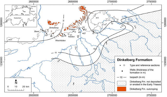
Outcrop and isopach map of the Dinkelberg Formation
- Type region:
-
Lower High Rhine area, between Basel and Etzgen AG
- Reference section:
-
Kaisten borehole, drilling metre 94.00–124.95 (Peters et al. 1989)
- Underlying strata:
-
Permian, mostly «Rotliegendes» (informal; in southern Germany: Weitenau Formation, Nitsch and Zedler 2009). At some localities, possibly «Zechstein» (informal, in southern Germany: Wiesental Formation, Nitsch and Zedler 2009)
- Lower boundary:
-
Onlaping unconformity. Conglomerates with walnut-sized triangular quartz-pebbles as suggested by Disler (1914) to mark the lower boundary are restricted to few areas and also occurs in higher levels of the Dinkelberg Formation. More indicative is the change from subangular and poorly sorted to well-rounded and well or bimodally sorted sandstones and conglomerates
- Overlying strata:
-
Kaiseraugst Formation (this paper)
- Upper boundary:
-
Unconformity. In most cases, the (due to pedogene processes) poorly-bedded reddish to green claystone of the Dinkelberg Formation is overlain by well-bedded, often fossiliferous (including brachiopods, bivalves, gastropods, and vertebrate remains), sometime silty to sandy greyish to yellow or olive marl followed by an alternation of grey dolomite and dark marl of the Kaiseraugst Formation (Disler 1914; Hofmann et al. 2000)
- Subdivision:
-
Formally not yet established. Traditional subdivision (from bottom to top): «Vogesensandstein», «Plattensandstein», and «Röt-Ton» (the Lower Buntsandstein Subgroup of southern Germany is missing in northern Switzerland)
- Occurrence:
-
Northern Switzerland, wedging out towards southeast along a line Langenthal–Zurich–Stein am Rhein (Fig. 4)
- Thickness:
-
Generally less than 40 m; up to 100 m in Basel area (Fig. 4)
- Chronostratigraphy:
-
No data from northern Switzerland, probably late Olenekian to early Anisian (Lepper et al. 2005)
- Description:
-
Mostly siliciclastic, mainly fluvial to coastal marine sediments: In the lower part, alternation of grey to green and red fine to coarse grained, often normally graded sandstone, containing different amounts of mica, sometimes cross bedded, with (to the upper part increasingly thicker) light to dark red marl to claystone, often with green spots. In the upper part, red claystone dominates. At different levels, intraformational conglomerates and breccias and pedogenic horizons with rusty red carneol, malachite, dolomite and anhydrite are found
- Lateral equivalents:
-
In the Lake Constance area (wells Berlingen-1, Kreuzlingen-1, Büchi et al. 1965), the reddish clays of the upper part of the formation are missing. The sandstone of the basal Dinkelberg Formation is followed by continental to coastal sediments, which are described, in southern Germany, as Eschenbach Formation and Grafenwöhr Formation (formerly «Muschelsandstein») representing the siliciclastic input from the Vindelician High in the East throughout the whole Muschelkalk Group (DSK 2005; Geyer et al. 2011). Büchi et al. (1965) summarised the basal «Buntsandstein» and the overlying siliciclastic sediments of the Seerücken area as «Basissand». Towards north, the Dinkelberg Formation corresponds to the Vogesensandstein Formation, Plattensandstein Formation and Rötton Formation of south-western Germany (e.g. Geyer et al. 2011). Towards south, the formation wedges out
- Interpretation:
-
The sequence documents two on-lapping transgressions coming from north corresponding to the youngest cycles of the German scheme (e.g. Geyer et al. 2011). The hiatus at the basal unconformity spans from latest Permian to probably early Olenekian

3 Kaiseraugst formation
3.1 Introduction
The Kaiseraugst Formation corresponds to the «Wellengebirge» as it was interpreted in the Swiss stratigraphic scheme (e.g. Müller et al. 1984, see also Fig. 3). It includes the basal «Wellendolomit», the «Wellenkalk» or «Wellenmergel», and the «Orbicularismergel» on top. In Germany, all three units are considered as own formations whereby the uppermost Karlstadt Formation is part of the Middle Muschelkalk Subgroup while the other two, Freudenstadt Formation and Jena Formation, form the Lower Muschelkalk Subgroup (Hagdorn and Simon 2005).
The abundance of consistently marine macrofossils distinguishes the formation from the underlying and overlying formations, where macrofossils are rare or absent.The only divergence to the former Swiss scheme concerns the bituminous «Unterer Dolomit» hitherto considered as the base of the «Anhydritgruppe», and now incorporated into the top of the Kaiseraugst Formation.
3.2 Definition of the Kaiseraugst Formation
- Names previously in use:
-
«Wellengebirge», further details are given in Fig. 3.
- Origin of the name:
-
Name of the Swiss municipality on the left bank of River Rhine where part of the composite type section is localized
- Type section:
-
The left and right banks of River Rhine north of Junkholz/Kaiseraugst AG, sections VI (coord. 2623.640/1265.975 to 2623.960/1265.950), VII (coord. 2622.750/1266.000 to 2622.075/1265.915) and VIII (coord. 2622.800/1265.775 to 2622.140/1265.725) by Disler (1914), now partly or fully flooded
- Type region:
-
Lower High Rhine area, between Basel and Schwaderloch AG
- Reference sections:
-
Kaisten borehole (coord. 2664.642/1265.624), drilling metre 46.40–94.00 (Peters et al. 1989): not fully cored and some core losses; but base and top—in a close to bedrock surface situation—are preserved. The transition from the overlying Schinznach Formation to the Kaiseraugst Formation (extending from drilling metre 749.44–793.90) is fully cored in the Riniken borehole (coord. 2656.605/1261.780), but the rest of the formation is not cored
- Underlying strata:
-
Dinkelberg Formation (this paper)
- Lower boundary:
-
Unconformity. In most cases, reddish to purple claystone of the Dinkelberg Formation are overlain by often fossiliferous (including brachiopods, bivalves, gastropods, and vertebrate remains), at some places silty to sandy greyish to yellow or olive marl is followed by an alteration of grey dolomite and dark marl (Disler 1914; Hofmann et al. 2000)
- Overlying strata:
-
Zeglingen Formation (this paper)
- Upper boundary:
-
Onset of the evaporitic facies. In most cases, the Zeglingen Formation starts with a massive anhydrite bed. In regard to clay mineralogy, the boundary corresponds to the onset of corrensite (e.g. Peters et al. 1989). On the other hand, bituminous shale and dolomite, abundant in the uppermost part of the Kaiseraugst Formation, disappear.
The often bituminous «Unterer Dolomit» hitherto considered as the base of the «Anhydritgruppe» is now incorporated at the top of the Kaiseraugst Formation.
N.B. Pedogenic horizons (dolocretes) and secondary sulfate deposits also occur in shale and dolomite of the Kaiseraugst Formation. The discrimination criterion for the identification of the Zeglingen Formation is the presence of massive sulfates
- Subdivision:
-
Formally not yet established. Traditional subdivision (from bottom to top): «Wellendolomit», «Wellenkalk» (or «Wellenmergel»), and «Orbicularis-Mergel»
- Occurrence:
-
Northern Switzerland, except Lake Constance area where the Kaiseraugst Formation is replaced by the «Basissand» of Büchi et al. (1965) which probably can be correlated with the «Muschelsandstein» of the Eschenbach Formation in southern Germany (e.g. Hagdorn and Simon, 2005). (See Fig. 5 and discussion in chapter 2.2)
Fig. 5 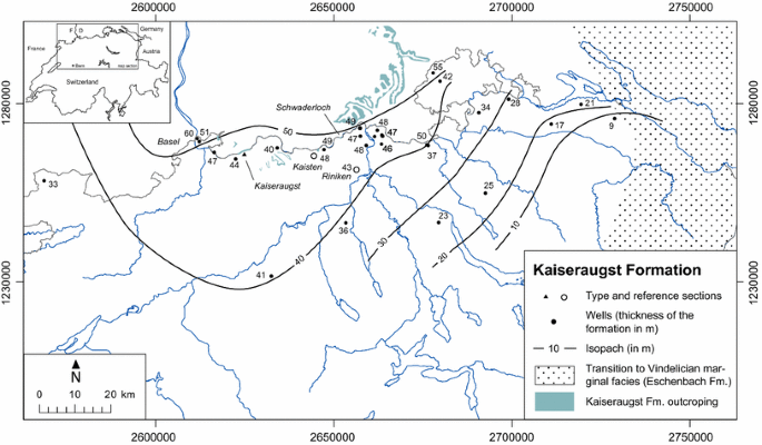
Outcrop, facies and isopach map of the Kaiseraugst Formation
- Thickness:
-
5–60 m (Fig. 5)
- Chronostratigraphy:
- Description:
-
Dolomite, (crinoidal) limestone, marl and shale, often rich in marine invertebrate fossils. Some levels contain galenite, sphalerite, chalcopyrite etc. (Hofmann 1985; Hofmann et al. 2000). In some levels, ripple marks are found. Horizons with dolocretes, desiccation cracks and roots document periods of emergence.
In general, the sedimentary succession starts with a transgressive sequence including partly sandy dolomite in alternation with dolomitic marl. The high stand is documented by an alternation of marl and subordinate limestone. The succession ends with bituminous shale. The overall transgressive–regressive cycle is superimposed by different subcycles (e.g. Götz 2002).
The fossil record includes cephalopods (ceratitida as Beneckeia buchi and nautilids), bivalves, gastropods, brachiopods, echinoderms. A typical fossil in the bituminous upper part is the bivalve Neoschizodus orbicularis (Myophoria orbicularis in old literature). See Disler (1914) for a comprehensive fossil list.
- Lateral equivalents:
-
The Kaiseraugst Formation corresponds to the Freudenstadt Formation, Jena Formation, and Karlstadt Formation of southern Germany (DSK 2005; Geyer et al. 2011). Towards east, in the Lake Constance area, the Kaiseraugst Formation is successively replaced by the Eschenbach Formation (DSK 2005; Geyer et al. 2011). Towards south, parts of the Mels Formation of the Helvetic domain may be correlated with the Eschenbach Formation and thus with the Kaiseraugst Formation (Frey 1968)
- Interpretation:
-
The sequence documents the setting up of a connection between the northern Central European Basin and the Tethys ocean. The NNE to SEE tending axis of this “Swabian seaway” can be localized east of today Black Forest reaching Northern Switzerland in the Schaffhausen area. It is charcterized by the domination of limestone facies during the maximum flooding while in lateral domains dolomite and siliclastic intercalations are more abundant (Hagorn and Nitsch 2009)

4 Zeglingen formation
4.1 Introduction
The Zeglingen Formation includes the Anisian evaporitic sequence and corresponds to the «Anhydritgruppe» («Mittlerer Muschelkalk») of the traditional Swiss scheme (e.g. Müller et al. 1984, see also Fig. 3. The only discrepancy concerns the «Unterer Dolomit» which is now part of the underlying Kaiseraugst Formation and was formerly considered as part of the «Anhydritgruppe» by some authors (c.f. Matter et al. 1988). One reason is that the German stratigraphic scheme incorporates the «Unterer Dolomit» into the Karlstadt Formation (former «Orbicularismergel»), which corresponds to the upper part of the Kaiseraugst Formation. On the other hand, a close examination shows that in most core reports, the boundary between «Wellengebirge» and «Anhydritgruppe» was set at the base of the first massive anhydrite sequence. The newly defined boundary also corresponds to the morphologic change from carbonate-dominated rocks (below), which resist erosion, to more soluble sulphates (above).
4.2 Definition of the Zeglingen formation
- Names previously in use:
-
«Anhydritgruppe», further details are given in Fig. 3.
- Origin of the name:
-
Name of the municipality where the type locality is situated
- Type section:
-
Gypsum quarry Wissbrunn in Zeglingen BL (coord. 2636.250/1251.300), Sect. 24 in Merki (1961)
- Type region:
-
Eastern Folded Jura
- Reference sections:
-
Böttstein borehole (coord. 2659.342/1268.556), drilling metre 197.20–261.00 (Peters et al. 1986): with the exception of a very short sequence, fully cored. Borehole S 106 (coord. 2619.825/1260.650) of Schweizer (Rhein-) Salinen AG, drilling metre 430.9–567.6 (Widmer 1991): fully cored
- Underlying strata:
-
Kaiseraugst Formation (this paper)
- Lower boundary:
-
Onset of the evaporitic facies. In most cases, the Zeglingen Formation starts with a massive anhydrite bed. In regard to clay mineralogy, the boundary corresponds to the onset of corrensite (e.g., Peters et al. 1986). On the other hand, bituminous shale and dolomite, abundant in the upper part of the Kaiseraugst Formation, disappear. The often bituminous «Unterer Dolomit» hitherto considered as the base of the «Anhydritgruppe» is now incorporated into the Kaiseraugst Formation. N.B. Pedogenic horizons (dolocretes) and secondary sulphate deposits in shale and dolomite also occur in the Kaiseraugst Formation. The discrimination criterion for the identification of the Zeglingen Formation is the presence of massive sulphates
- Overlying strata:
-
Schinznach Formation [Pietsch et al. 2015 (submitted/this volume)]
- Upper boundary:
-
Onset of thick bedded limestone and dolomite above finely bedded (stromatolitic) dolomite and, thus, termination of evaporitic sabkha facies of the Zeglingen Formation by subtidal marine carbonates (initially all limestone, now, in some regions partially dolomitised)
- Subdivision:
-
Formally not yet established. The traditional subdivision (e.g. Widmer, 1991), from bottom to top: «Untere Sulfatzone», «Salzlager», «Obere Sulfatzone», and «Dolomitzone» (or «Anhydritdolomit») can be further subdivided in eight subunits which can be correlated between the main borehole sections (Dronkert et al. 1990)
- Occurrence:
-
Northern Switzerland; rock salt deposits («Salzlager», informal) are restricted to an area northwest of a line Bern–Zurich–Schaffhausen (Fig. 6); in the outcrop area rock salt and—in a different extent—sulphates are missing due to subrosion. They are represented by residual clay and collapse breccia
Fig. 6 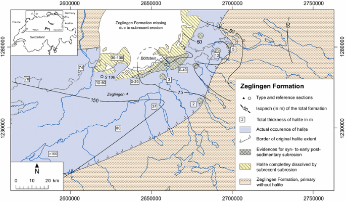
Facies and isopach map of the Zeglingen Formation. Occurence of rock salt deposits in Blumberg area following Bock and Simon (2009)
- Thickness:
-
40–150 m (Fig. 6)
- Chronostratigraphy:
-
Anisian (Illyrian) (e.g., Hagdorn and Simon 2005; Geyer et al. 2011)
- Description:
-
Massive and layered anhydrite (near surface: gypsum), rock salt, insets and alternations of shale and dolomite often containing magnesite, coelestine etc.; residuals like clay and breccias are found along the superficial outcrop area, as well as at several sites of syn- to early post-sedimentation subrosion (Dronkert et al. 1990) throughout the entire area (see Fig. 6)
- Lateral equivalents:
-
The Zeglingen Formation corresponds to the Heilbronn Formation and Diemel Formation of south-western Germany (DSK 2005; Geyer et al. 2011). Towards east, in the Lake Constance area, the Zeglingen Formation may be replaced by the siliciclastic fluvial Grafenwöhr Formation (DSK 2005; Geyer et al. 2011). However, Büchi et al. (1965) reports for the Benken, Berlingen and Kreuzlingen wells (Fig. 2) still the presence of sulphate sediments, i.e. the Zeglingen Formation. Towards south, the Zeglingen Formation may correspond to the lower parts of the Röti Formation of the Helvetic domain (Frey 1968)
- Interpretation (Fig. 6):
-
The Swiss salina basin with rock salt deposits in its centre is part of a greater marine system extending from the northern Central European basin to the south along proto Rhenish structures and further to the Burgundy basin in the Lyon area in France (Hagorn and Nitsch 2009). Dronkert et al. (1990) recognised a transgressive–regressive megacycle with eight meso-sequences and many sub-sequences. The marine salt deposits document a high stand which is followed by a regression ending in a sabkha type costal environment

5 Definition of stratigraphic groups in the Triassic of northern Switzerland
5.1 Introduction
Especially for mapping purposes and for the practical grouping of lithostratigraphic units for reports and core descriptions, the following stratigraphic groups are defined for Northern Switzerland in dependence to the German stratigraphic scheme (Alberti 1834, 1864, for actual interpretation see, e.g., Geyer et al. 2011) but with a small divergence:
5.2 Buntsandstein Group
- Name previously in use:
-
«Buntsandstein» (further details are given in Fig. 3).
- Subdivision:
-
Dinkelberg Formation (this paper)
- Origin of the name:
-
Traditional name, referring to the variegated (mainly red) color of the rocks, introduced to the stratigraphy by Abraham Gottlob Werner in 1780 (Hagdorn and Nitsch 1999)
- Underlying group:
-
Zechstein or Rotliegend Group (informal in Switzerland, formally defined in Germany, e.g. Geyer et al. 2011)
- Overlying group:
-
Muschelkalk Group (this paper)
- Chronostratigraphy:
-
Olenekian to Anisian (DSK 2002)
- Lateral equivalents:
-
Towards north and north-east: Upper part of the Buntsandstein Group of the southern Germany stratigraphic scheme (e.g. Geyer et al. 2011) which includes also older formations with no equivalents in Switzerland (hiatus). Towards south: parts of the Buntsandstein Group possibly corresponds to the Mels Formation of the Helvetic domain (Frey 1968)
5.3 Muschelkalk Group
- Name previously in use:
-
«Muschelkalk » (further details are given in Fig. 3).
- Subdivision:
-
Kaiseraugst Formation (this paper), Zeglingen Formation (this paper) and Schinznach Formation [Pietsch et al. 2015 (submitted/this volume)]
- Origin of the name:
-
Traditional name, referring to abundance of shells (mainly from brachiopods) at some places, introduced to the stratigraphy by Georg Christian Füchsel in 1761 (Hagdorn and Nitsch 1999)
- Underlying group:
-
Buntsandstein Group (see above)
- Overlying group:
-
Keuper Group (see below)
- Chronostratigraphy:
-
Anisian to Ladinan (DSK 2002)
- Lateral equivalents:
-
Toward north and north-east: Muschelkalk Group of the southern Germany stratigraphic scheme (e.g. Geyer et al. 2011) together with the underlying Erfurt Formation which is part of the German Keuper group but correlates to the Asp Member of the Schinznach Formation in Switzerland [Pietsch et al. 2015 (submitted/this volume)]. Towards south: Parts of the Muschelkalk Group corresponds to the Mels and Röti Formation of the Helvetic domain (Frey 1968), while other parts are wedging out
5.4 Keuper Group
- Name previously in use:
-
«Keuper» (further details are given in Fig. 3).
- Subdivision:
-
Klettgau Formation [Jordan et al. 2015 (submitted/this volume)] and Bänkerjoch Formation [Jordan et al. 2015 (submitted/this volume)]
- Origin of the name:
-
Traditional description of crumbly marl on top of the «Muschelkalk» in southern Germany, for the first time introduced in the geological literature independently by Leopold von Buch, Friedrich Hoffmann und Christian Keferstein in the 1820’s (Hagdorn and Nitsch 1999; Nitsch 2005)
- Overlying group:
-
«Lias » (informal, incorporates only the Staffelegg Formation, Reisdorf et al. 2011)
- Underlying group:
-
Muschelkalk Group (see above)
- Chronostratigr. age:
-
Ladinian–Rhaetian (DSK 2005)
- Lateral equivalents:
-
Towards north and north-east: Keuper Group of the southern Germany stratigraphic scheme (Etzold and Schweizer 2005) exclusive of the Erfurt Formation (DSK 2005) which correlates to the Asp Member of the Schinznach Formation (see above)
- Towards south:
-
Parts of the Keuper Group correspond to the Quarten Formation of the Helvetic domain, while other parts are wedging out [(Frey 1968; Jordan et al. 2015 (submitted/this volume)]
References
Alberti, F.V. (1834). Beitrag zu einer Monographie des Bunten Sandsteins, Muschelkalks und Keupers und die Verbindung dieser gebilde zu einer Formation. Verlag der J. G. Cottaschen Buchhandlung, Stuttgart und Tübingen, p. 366.
Alberti, F.V. (1864). Übersicht über die Trias mit Berücksichtigung ihres Vorkommens in den Alpen. Verlag der J. G. Cottaschen Buchhandlung, Stuttgart, p. 353.
Bitterli, T., Graf, H.R., Matousek, F., & Wanner, M. (2000). Blatt 1050 Zurzach. Geol. Atlas der Schweiz 1:25,000, Erläuterungen 102. Bundesamt für Wasser und Geologie, Bern, p. 98.
Bitterli-Brunner, P., & Fischer, H. (1988). Erläuterungen zu Blatt 80 Arlesheim des Geol Atlas der Schweiz. Hg. von der Landeshydrologie und -geologie, p. 66.
Bitterli-Dreher, P., Graf, H.R., Naef, H., Diebold, P., Matousek, F., Burger, H., & Pauli-Gabi, T. (2007). Blatt 1070 Baden. Geol. Atlas der Schweiz 1:25,000, Erläuterungen 120. Bundesamt für Landestopografie swisstopo, p. 152.
Bläsi, H.R. (1995). Fazies, Diagenese und wasserführende Systeme in den kalkigen und sandigen sedimentkörpern von Schilfsandstein bis Dogger beta in den Bohrungen Lindau-1, Herdern-1, Berlingen-1, Kreuzlingen-1 und Meersburg-1, Teil 1: Fazies und Stratigraphie. Unpubl. Nagra Interner Ber. Nagra, Wettingen.
Bock, H., & Simon, T. (2009). Steinsalzverbreitung im Mittleren Muschelkalk in Baden-Württemberg und der angrenzenden Schweiz. 1 map; Freiburg i.Br. (Landesamt für Geologie, Rohstoffe und Bergbau). (http://www.lgrb-bw.de/download_pool/steinsalzverbreitung.pdf).
Brändlin, E. (1911). Zur Geologie des nördlichen Aargauer Tafeljura zwischen Aare- und Fricktal., Verhandlungen der Naturforschenden Gesellschaft Basel XXII, p. 96.
Büchi, U. P., Lemcke, K., Wiener, G., & Zimdars, J. (1965). Geologische Ergebnisse der Erdölexploration auf das Mesozoikum im Untergrund des schweizerischen Molassebeckens. Bulletin der Schweizerischen Vereinigung von Petroleum-Geologen und -Ingenieuren, 15, 7–38.
Disler, C. (1914). Stratigraphischer Führer durch die geologischen Formationen im Gebiet zwischen Aare, Birs und Rhein. Basel, B. Wepf & Co, p. 37.
Dronkert, H. (1987). Diagenesis of Triassic evaporites in northern Switzerland. Eclogae Gologicae Helvetiae, 80, 397–413.
Dronkert, H., Bläsi, H.R., & Matter, A. (1990). Facies and origin of triassic evaporites from the Nagra boreholes. Technischer Bericht, NTB 87-02. Nagra, Wettingen 80, (pp. 397–413).
DSK. (2002). Stratigraphische Tabelle von Deutschland 2002. Tafel 96 × 130 cm oder Falt-Tafel A4; Potsdam (GeoForschungsZentrum), Frankfurt a. M. (Forsch.-Inst. Senckenberg).
DSK. (2005). Deutsche Stratigraphische Kommission (Hrsg. Beutler, G., Hauschke, N., Nitsch, E. & Vath, U.). Stratigraphie von Deutschland IV—Keuper. Courier Forschungsinstitut Senckenberg, 253, 1–296.
Équipe du projet GeORG (2013). Potentiel géologique profond du Fossé rhénan supérieur, Rapport scientifique et technique du projet Interreg GeORG, Part 4, Atlas, Freiburg i. Br./Mainz/Strasbourg/Basel, p. 104.
Erni, A. (1910). Das Rhät im schweizerischen Jura. Eclogae Geologicae Helvetiae, 11, 5–54.
Etzold, A., & Bläsi, H.R. (2000). Jahrestreffen der AG-Keuper in der Perm-Trias-Subkommission 20–23. 07. 2000 in Waldshut-Tiengen. Field Guide, p. 9.
Etzold, A., & Schweizer, V. (2005). Der Keuper in Baden-Württemberg. Deutsche Stratigraphische Kommission, 2005: Stratigraphie von Deutschland IV: Keuper. Cour. Forsch.-Inst Senckenberg, 253, 214–258.
Fischer, H. (1969). Übersichtstabelle zur Geologie der weiteren Umgebung von Basel: (südlicher Sundgau, östliche Ajoie, Delsberger Becken, Basler und Aargauer Tafeljura bis Fricktal, Dinkelberg). Geographischer Exkursionsführer der Region Basel/Hrsg. von der Geographisch-Ethnologischen Gesellschaft Basel, p. 2.
Frey, M. (1968). Quartenschiefer, Equisetenschiefer und germanischer Keuper: ein lithostratigraphischer Vergleich. Eclogae Geologicae Helvetiae, 61, 141–156.
Geyer, M., Nitsch, E. & Simon, T. (2011). Geologie von Baden-Württemberg (established by Geyer, O.F., and Gwinner, M.P.). 5., völlig neu bearbeitete Auflage, Schweizerbart Stuttgart 2011, p. 627.
Götz, A. E. (2002). Hochauflösende Stratigraphie im Unteren Muschelkalk (Mitteltrias, Anis) des Germanischen Beckens. In W. Rosendahl & A. Hoppe (Ed.), Angewandte Geowissenschaften in Darmstadt. Schriftenreihe der Deutschen Geologischen Gesellschaft, Heft 15 (pp. 101–107).
Gsell, F. (1968). Geologie des Falten- und Tafeljura zwischen Aare und Wittnau und Betrachtungen zur Tektonik des Ostjura zwischen dem Unteren Hauenstein im W und der Aare im E. Univ. Zürich Inaugural-Dissertation, p. 138.
Gürler, B., Hauber, L., & Schwander, M. (1987). Die Geologie der Umgebung von Basel, mit Hinweisen über die Nutzungsmöglichkeiten der Erdwarme. Beitr. geol. Karte Schweiz [NF] 160, p. 33.
Hagdorn, H., & Nitsch, E. (1999). Zum Begriff „Trias” Ein geschichtlicher Abriss. In Hauschke, N. & Wilde, V. (Ed.), Trias, eine ganz andere Welt: Europa im frühen Erdmittelalter (pp. 13–21). München (Pfeil).
Hagdorn, H., & Simon, T. (2005). Der Muschelkalk in der Stratigraphischen Tabelle von Deutschland 2002. Newsletters on Stratigraphy, Stuttgart, 2005(41), 143–158.
Hagorn, H., & Nitsch, E. (2009). Field Guide, 6th International Triassic field Workshop, September 7–11, 2009. Tübingen, p. 72.
Hauber, L. (1971). Zur Geologie des Salzfeldes Schweizerhalle-Zinggibrunn (Kt. Baselland). Ecologae Geologicae Helvetiae, 64, 163–183.
Hauber, L., Noher, H.P., Meyer, M., & Horal, G. (2000). Geologie im Bereich Adlertunnel. tec21 49/50 (2000), pp. 9–12.
Heidbach, O., Hergert, T., Reiter, K., & Giger, S. (2014). Local stress field sensitivity analysis—Case Study Nördlich Lägern. Nagra Arbeitsbericht. NAB (pp. 13–88). Nagra, Wettingen.
Herzog, P. (1956). Die Tektonik der Rheintalflexur und des Tafeljura südöstlich von Basel. Eclogae Geologicae Helvetiae, p. 49.
Hofmann, F. (1981). Geologischer Atlas der Schweiz 1:25,000, Blatt 1031 Neunkirch. Erläuterungen 74. Bundesamt für Landestopografie, swisstopo, Bern, p. 49.
Hofmann, B. (1985). Mineralisationen von Pb, Zn, Cu und As in der Trias des südwestlichen Schwarzwaldrandes. Das Kristallin an der oberen Wutach als Beispiel eines möglichen Liefergebietes von Sedimentmaterial und erzbildenden Elementen. Unpubl. Lizentiatarbeit Universität Bern, p. 188.
Hofmann, F., Schlatter, R., & Weh, M. (2000). Erläuterungen zu Blatt 97: Beggingen (LK 1011) des Geologischen Atlas der Schweiz 1:25,000. Bundesamt für Wasser und Geologie, Bern, p. 113.
Jordan, P. (1992). Evidence for large-scale decoupling in the Triassic evaporites of northern Switzerland—an overview. Eclogae Geologicae Helvetiae, 85, 677–693.
Jordan, P. (2008). Triassic. Basin Evolution: Switzerland. In McCann, T. (Ed.), The geology of Central Europe, vol. 2: Mesozoic and Cenozoic—Geol. Soc., London., (pp. 785–788).
Jordan, P., Eberhard, M., Graf, H.R., Diebold, P., Jost, J., & Schürch, R. (2011). Geologischer Atlas der Schweiz 1:25’000, Blatt 1089 Aarau. Mit Erläuterungen. Bundesamt für Landestopografie, swisstopo, Bern, p. 156.
Jordan, P., Pietsch, J., Bläsi, H.R., Furrer, H., Kündig, N., Looser, N., Wetzel, A., & Deplazes, G. (2015). The Middle to Late Triassic Bänkerjoch and Klettgau Formations of northern Switzerland. to be published in THIS VOLUME of Swiss Journal of Geosciences (Harmos Project volume) (submitted).
Lepper, J., Rambow, D., & Röhling, H.-G. (2005). Der Buntsandstein in der Stratigraphischen Tabelle von Deutschland 2002. Newsletters on Stratigraphy, Stuttgart, 2005(41), 129–142.
Matter, A., Peters, T., Bläsi, H.-R., Meyer, J., Ischi, H., & Meyer, C. (1988). Sondierbohrung Weiach, Geologie, Nagra NTB 86-01, p. 438.
Meier, I. (2011). Sulfur isotopes of Gipskeuper and Anhydritgruppe in Northern Switzerland. Master Thesis, ETH Zurich, p. 163.
Merki, P. J. (1961). Der Obere Muschelkalk im östlichen Schweizer Jura. Eclogae Geologicae Helvetiae, 54, 137–219.
Morard, A. et al. (2012). Lithostratigraphy of Switzerland: Options and challenges for a harmonisation. 10th Swiss Geoscience Meeting abstract volume, p. 173.
Mühlberg, F. (1908). Geologische Karte der Umgebung von Aarau, 1: 25,000. Geol. Spezkarte, Erläut. 45, p. 94.
Müller, A. (1876). Beschreibung der Bohrkernserie des Weyherfeldes (bei Rheinfelden). Bericht des Verwaltungsrathes der Schweizerischen Steinkohlengesellschaft an die Generalversammlung der Aktionäre. Mit einem Bohrprofil durch Buntsandstein, Rotliegendes und Grundgebirge.
Müller, W.H., Huber, M., Isler, A., & Kleboth, P. (1984). Erläuterungen zur Geologischen Spezialkarte Nr. 121 der zentralen Nordschweiz 1:100,000 mit angrenzenden Gebieten von Baden-Württemberg. Baden: Nationale Genossenschaft für die Lagerung radioaktiver Abfälle (NAGRA) und Schweizerische Geologische Kommission, p. 234.
Nagra (2001). Sondierbohrung Benken. Untersuchungsbericht. Nagra Tech. Ber. NTB 00–01. Nagra, Wettingen, Textband, p. 288.
Nitsch, E. (2005). Zur Geschichte der Keuperstratigraphie. Deutsche Stratigraphische Kommission, 2005: Stratigraphie von Deutschland IV: Keuper. Cour. Forsch.-Inst Senckenberg, 253, 6–14.
Nitsch, E., & Zedler, H. (2009). Oberkarbon und Perm in Baden-Württemberg. LGRB-Informationen, vol. 22, (pp. 7–102). Freiburg i.Br.
Paul, W. (1936). Der Hauptmuschelkalk am südöstlichen Schwarzwald. Mitt. Bad. geol. L.-A. 11, 4, p. 23.
Paul, W. (1956). Zur Stratigraphie und Fazies des Oberen Muschelkalkes zwischen oberem Neckar und Hochrhein. Schr. Landkr. Donaueschingen, p. 8.
Paul, W. (1971). Die Trias. In Sauer, K.F.J, Schnetter, M. (Eds.), Die Wutach. Freiburg i. Br.: Badischer Landesverein für Naturkunde und Naturschutz e. V., (pp. 37–115).
Peters, T. J. (1964). Tonmineralogische Untersuchungen an einem Keuper-Lias-Profil im Schweizer Jura (Frick). Schweizerische Mineralogische und Petrographische Mitteilungen, 44, 1–30.
Peters, TJ., Matter, A., Bläsi, H.R., & Gautschi, A. (1986). Sondierbohrung Böttstein. Geologie. Nagra Tech. Ber. NTB 85-02. Nagra, Wettingen, Textband, p. 207.
Peters, TJ., Matter, A., Meyer, J., Isenschmid, C., & Ziegler, H.J. (1989). Sondierbohrung Kaisten. Geologie. Nagra Tech. Ber. NTB 86–04. Nagra, Wettingen, Textband, p. 286.
Pietsch, J., Wetzel, A., & Jordan, P. (2015). A new lithostratigraphic scheme for Schinznach Formation (Upper Muschelkalk of Northern Switzerland). to be published in THIS VOLUME of Swiss Journal of Geosciences (Harmos Project volume) (submitted).
Prasad, N. (1970). Sedimentology of Keuper from the Belchen-Tunnel eastern Swiss Jura. Thesis, Basel, p. 16.
Reisdorf, A. G., Wetzel, A., Schlatter, R., & Jordan, P. (2011). The Staffelegg Formation: a new stratigraphic scheme for the Early Jurassic of northern Switzerland. Swiss Journal of Geosciences, 104, 97–146.
Remane, J., Adatte, T., Berger, J.-P., Burkhalter, R., Dall’Agnolo, S., Decrouez, D., et al. (2005). Richtlinien zur stratigraphischen Nomenklatur. Eclogae Geologicae Helvetiae, 98, 385–405.
Rick, B. (1990). Geotechnische und hydrochemische Folgen der Verwitterung sulfathaltiger Gesteine (Gipskeuper des Schweizer Jura) Diss. Naturwiss. ETH Zürich, Nr. 9257, p. 162.
Ryf, W. (1984). Die Thermalwasserbohrung 1983 Engerfeld, Rheinfelden. Rheinfelder Neujahrsblätter, 1984, 43–52.
Schalch, F. (1916). Geologische Spezialkarte des Grossherzogtums Baden. Erläuterungen zu Blatt Wiechs-Schaffhausen (Nr. 145). Heidelberg: Carl Winter’s Universitätsbuchhandlung, p. 176.
Schindler, C. (1962). Gipsvorkommen zwischen Riepel und Staffelegg. Unpubl. Gutachten geotechnisches Büro Dr. A. von Moos für Jura-Cementfabrik Aarau-Wildegg.
Strasky, S., Morard, A., & Möri, A. (2015). XXX to be published in THIS VOLUME of Swiss Journal of Geosciences (Harmos Project volume) (submitted).
Widmer, T. (1991). Zur Stratigraphie und Sedimentologie der Anhydritgruppe (Mittlere Trias) in der Region Liestal—Arisdorf (Baselland, Nordwestschweiz). Beitr. Geol. Schweiz, geotechnische Serie 79, p. 108.
Wildi, W. (1976). Die Molluskenfauan des Gansinger Dolomits (Trias, Karnian, Mittlerer Keuper) im aargauischen Tafeljura (Nordschweiz). Eclogae Geologicae Helvetiae, 69, 671–684.
Acknowledgments
This paper has benefited from valuable discussions, constructive reviews and useful suggestions from Peter Bitterli-Dreher, Hansruedi Bläsi, Reto Burkhalter, Gaudenz Deplazes, Andreas Etzold, Hans Hagdorn, Heinz Furrer, Alain Morard, Edgar Nitsch, Johannes Pietsch and Andreas Wetzel. Special thanks are also due to the members of the Swiss Committee for Stratigraphy, and, especially of the Eastern Jura Mountains sub group. The Swiss Geological Survey is thanked for financial support.
Author information
Authors and Affiliations
Corresponding author
Additional information
Communicated by W. Winkler and A. Morard.
Rights and permissions
About this article

Cite this article
Jordan, P. Reorganisation of the Triassic stratigraphic nomenclature of northern Switzerland: overview and the new Dinkelberg, Kaiseraugst and Zeglingen formations. Swiss J Geosci 109, 241–255 (2016). https://doi.org/10.1007/s00015-016-0209-4
Received:
Accepted:
Published:
Issue Date:
DOI: https://doi.org/10.1007/s00015-016-0209-4